My Surveyor Local uses cutting-edge technology to provide comprehensive property inspections. Modern surveying equipment identifies issues traditional methods might miss, giving buyers more detailed information for informed decisions. This guide explores advanced survey technology and its benefits.
Evolution of Property Surveying
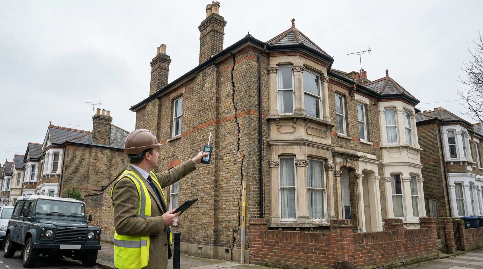
Property surveying has transformed dramatically in recent years. Traditional surveys relied on visual inspection, ladders for limited roof access, and basic tools like spirit levels and tape measures. While surveyors' professional expertise remains crucial, modern technology supplements their skills with precise data and detailed documentation.
Today's RICS chartered surveyors use thermal imaging cameras, electronic moisture meters, drones, laser distance measurers, and digital reporting systems. These tools don't replace professional judgment but enhance accuracy, provide evidence, and identify problems invisible to naked eyes.
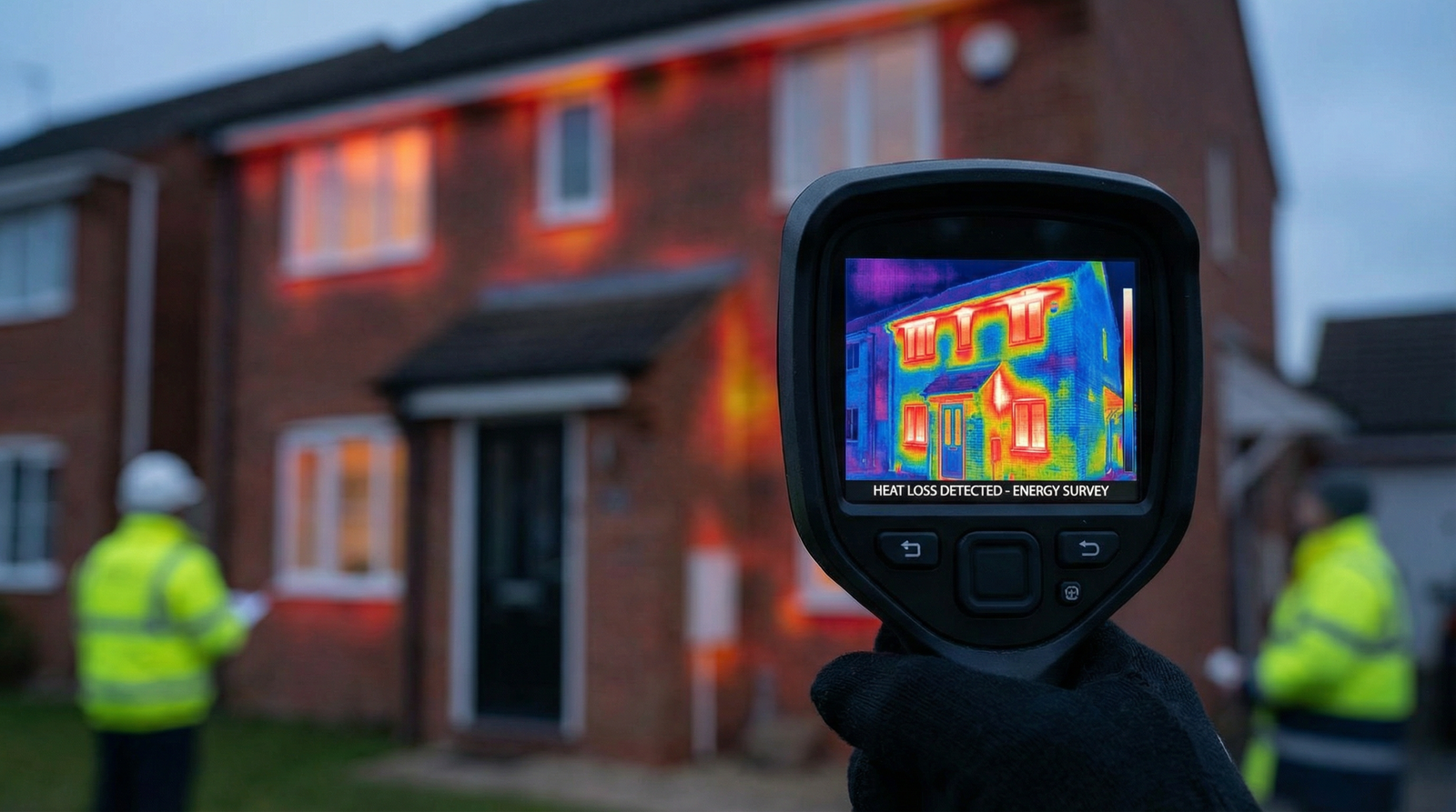
Thermal Imaging Technology
Thermal imaging cameras detect heat patterns in buildings, revealing problems invisible during standard inspections.
How Thermal Imaging Works
Thermal cameras measure infrared radiation (heat) emitted by surfaces. Different temperatures appear as different colors in images, typically red/orange for warm areas and blue/purple for cool spots. Temperature variations indicate potential problems like insulation gaps, air leaks, moisture ingress, or heating system issues.
What Thermal Imaging Reveals
Hidden Dampness: Damp areas appear cooler than surrounding dry surfaces due to evaporation. Thermal imaging identifies moisture problems behind plaster, under floors, or within walls without invasive testing.
Insulation Defects: Missing or inadequate insulation shows as cold spots in thermal images. Surveyors identify where heat escapes, helping prioritize energy efficiency improvements.
Air Leakage: Gaps around windows, doors, or service penetrations allowing drafts show clearly in thermal images. These air leaks waste energy and reduce comfort.
Heating System Problems: Underperforming radiators, blocked pipes, or faulty underfloor heating appear in thermal scans, identifying issues requiring attention.
Electrical Faults: Overheating electrical connections or circuits show as hot spots in thermal images, indicating potentially dangerous faults requiring immediate investigation.
Limitations of Thermal Imaging
While powerful, thermal imaging has limitations. It requires temperature differences between problem areas and surroundings. In consistently cold or warm conditions, contrast might be insufficient. External weather affects readings - wind, rain, or direct sunlight can interfere. Results require professional interpretation; thermal images don't automatically diagnose problems but provide evidence requiring expert analysis.
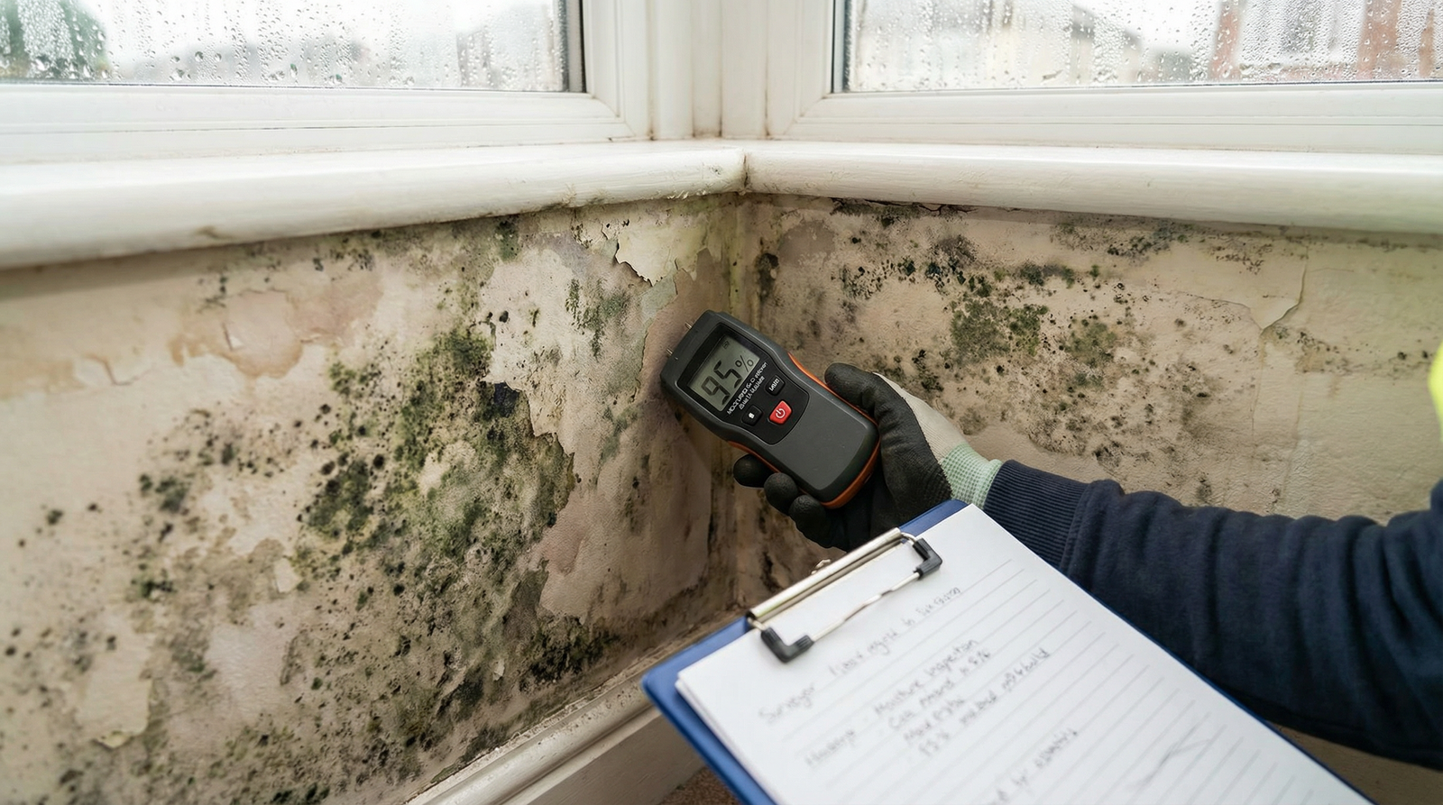
Electronic Moisture Meters
Modern moisture meters provide accurate, non-invasive damp detection.
Types of Moisture Meters
Pin-type Meters: Insert two pins into materials measuring electrical resistance. Higher moisture content means lower resistance. These meters provide precise readings at specific points but require minor surface penetration.
Non-invasive Meters: Scan surfaces without penetration using electromagnetic sensors. They detect moisture over larger areas quickly but with slightly less precision than pin meters.
Experienced surveyors use both types, employing non-invasive meters for broad scanning and pin meters for precise measurement where moisture is suspected.
Benefits Over Traditional Methods
Traditional damp testing relied on visual inspection and tactile assessment (touching walls feeling for dampness). Modern moisture meters provide objective numerical data, enabling accurate severity assessment and comparison over time. Readings quantify moisture levels precisely, distinguishing between minor surface condensation and serious damp requiring treatment.
Readings above 20% indicate potential damp problems, while readings over 25% suggest significant moisture issues. These objective measurements remove guesswork and provide clear evidence for reports and negotiations.
Drone Technology in Surveying
Drones revolutionize roof and chimney inspections, providing detailed views without scaffolding or cherry pickers.
Drone Inspection Capabilities
Roof Surveys: Drones capture high-resolution photographs and videos of entire roof surfaces from multiple angles. Surveyors identify missing tiles, damaged flashings, chimney issues, and gutter problems without physically accessing roofs.
Tall Buildings: For multi-story properties, flats, or buildings with access difficulties, drones inspect upper floors, parapets, and other areas traditionally requiring expensive access equipment.
Detailed Documentation: Drone footage provides permanent visual records of property conditions, supplementing written reports with clear photographic evidence buyers can review.
Safety Benefits: Drones reduce surveyor risk by eliminating dangerous roof access. This is particularly important for fragile roofs, steep pitches, or properties where access poses safety concerns.
Limitations and Regulations
Drone use requires CAA (Civil Aviation Authority) approval and appropriate insurance. Weather conditions affect drone operations - strong winds, rain, or poor visibility prevent flying. While drones provide excellent visual inspection, they can't assess roof structures internally or investigate under tiles like physical access permits. They complement but don't entirely replace traditional methods.
Laser Distance Measurers
Laser measuring tools provide precise dimensions instantly.
Applications in Surveying
Traditional tape measures require two people for long distances and provide opportunities for measurement errors. Laser measurers allow single surveyors to measure accurately to millimeters. They calculate room volumes automatically, measure inaccessible areas (high ceilings, across voids), and provide consistent accuracy eliminating human measurement errors.
Precise measurements help identify structural anomalies, verify floor areas match property particulars, and provide accurate data for report diagrams and floor plans.
Digital Reporting Systems
Modern surveys use digital systems for comprehensive documentation.
On-Site Digital Recording
Surveyors use tablets or smartphones with specialized apps to record findings immediately during inspections. They photograph issues, annotate images, record moisture readings, add location notes, and begin report writing on-site while details are fresh.
This real-time documentation ensures nothing is forgotten and reduces time between inspections and report delivery. Digital systems link photographs directly to relevant report sections, providing clear visual evidence for every finding.
Enhanced Report Quality
Digital reports include high-quality photographs, annotated diagrams highlighting issues, embedded moisture meter readings, thermal images where appropriate, and clickable navigation allowing easy reference between sections.
Professional presentation makes reports clearer and more accessible for buyers unfamiliar with technical surveying terms.
Borescopes and Endoscopes
Inspection cameras allow surveyors to see inside walls, under floors, and in other inaccessible spaces.
What Borescopes Reveal
Small cameras on flexible cables or rigid probes insert through tiny holes (often existing service penetrations) to inspect: cavity walls for insulation or moisture, under-floor spaces for timber condition, behind bath panels or fitted furniture, inside chimneys and flues, and roof voids with limited access.
This technology identifies problems without extensive removal of fixtures, fittings, or finishes, reducing inspection costs and property disruption.
3D Laser Scanning
Advanced surveys sometimes use 3D laser scanning creating detailed three-dimensional property models.
Applications
While less common in standard residential surveys due to costs, 3D scanning benefits complex properties, heritage buildings, or properties requiring detailed measured surveys. Scans create accurate digital twins enabling: precise structural analysis, planning for extensions or alterations, heritage documentation, and virtual tours for remote review.
As technology costs decrease, 3D scanning may become more common in mainstream surveying.
Integration With Traditional Skills
Technology enhances but doesn't replace surveyor expertise. Professional judgment, experience, and knowledge remain essential for interpreting technological data correctly.
Technology provides data - surveyors provide context, understanding, and recommendations. Thermal images show temperature variations, but surveyors determine whether they indicate serious problems or minor issues. Drones capture roof images, but experienced surveyors assess whether visible defects are cosmetic or structural.
The most effective surveys combine cutting-edge technology with decades of professional experience, giving buyers comprehensive, accurately-interpreted information.
Benefits for Property Buyers
Modern survey technology benefits buyers through:
More Detailed Information: Technology reveals problems traditional methods might miss, providing more complete property assessments.
Better Evidence: Photographs, thermal images, and precise measurements provide objective evidence supporting survey findings and negotiations.
Faster Reports: Digital systems and on-site recording reduce time between inspections and report delivery.
Clearer Understanding: Visual evidence helps buyers understand issues better than written descriptions alone.
Reduced Costs: Technology sometimes eliminates needs for expensive invasive investigations, keeping overall survey costs reasonable while improving quality.
Conclusion
Modern survey technology has transformed property inspections, providing more detailed, accurate assessments than ever before. Thermal imaging, drones, moisture meters, and digital reporting systems help RICS surveyors identify issues, document conditions comprehensively, and deliver professional reports with clear evidence.
My Surveyor Local connects buyers with surveyors using latest technology alongside traditional expertise, ensuring you receive thorough, professional assessments providing complete peace of mind about your property purchase.
Want a Survey Using Modern Technology?
Contact My Surveyor Local to find surveyors using cutting-edge equipment for comprehensive property inspections.
Get Your Free Quote